The East-West Connection – a Bicycle Route from the W&OD to Mustang Alley, and Other Updates to the Bicycle Master Plan
Summary
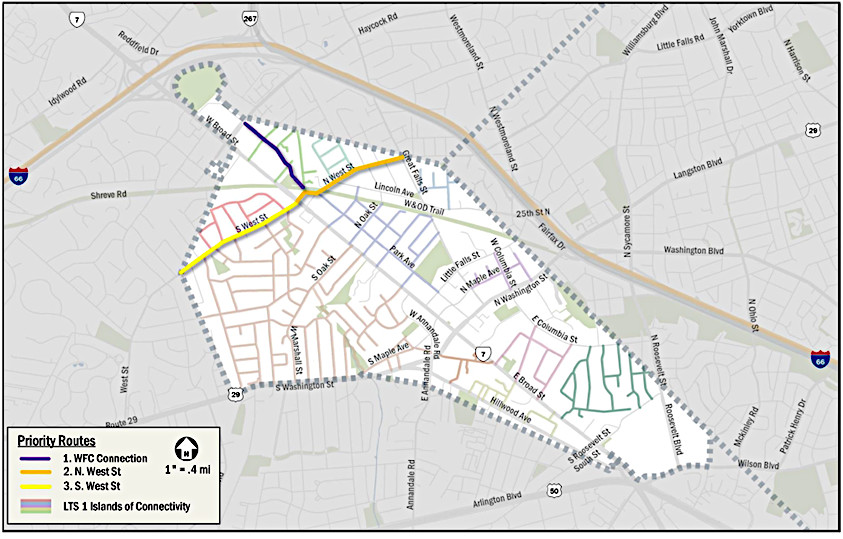
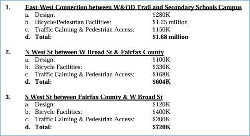
- Staff presented the conceptual designs and initial high-level cost estimates for three bicycle routes in the Bicycle Master Plan:
- The East-West Connection ($1.68 million)
- S West Street ($604,000)
- N West Street ($720,000)
- Details of the East-West connection are included in this post.
- The West Street route could begin implementation as early as Fall 2025.
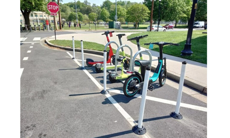
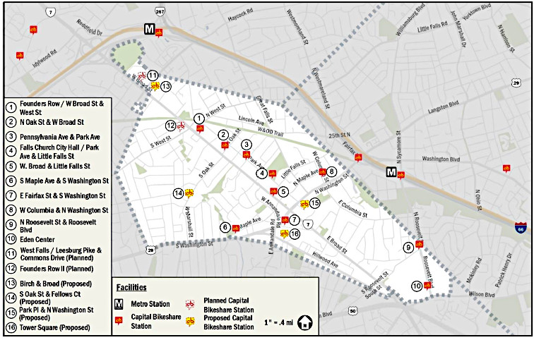
- Four Capital Bikeshare stations have been proposed in the City in addition to the two already planned at West Falls and Founders Row. These will be funded by a $481,000 federal grant.
- Final consideration by the City Council is expected at Council’s September 23 meeting.
Background
At the Citizens Advisory Committee on Transportation (CACT) meeting of August 21, 2024, and the City Council work session of August 5, 2024, staff presented an update to the Bicycle Master Plan (BMP) that was first presented to the City Council at its February 5, 2024, work session. [Read Pulse post The 2024 Bicycle Master Plan.]
City staff then provided design options for six of the priority routes. They focused on three routes – S West St, N West St, and the East-West Connection – and held three community walking tours in June to receive feedback. [Read Pulse post Options to Incorporate Bike Lanes Along West Street, Park Avenue, Broad Street and Great Falls Street.] Based on considerable feedback including phone conversations with residents, staff have proposed a conceptual design for these three routes in the BMP update.
The East-West Connection, a pedestrian and bicycle route to link the W&OD Trail to the Secondary Schools campus at Mustang Alley, was recommended in a study by consultant Rossi Transportation Group. This post includes details of the proposed East-West Connection. Details of the West Street routes can be found in our earlier post.
The BMP update also includes the addition of four more bikeshare stations in the City.
This BMP update, scheduled for final consideration by the City Council at its September 23 meeting, will authorize staff to continue to improve the designs for these three priority routes. Implementation of the N West St and S West St routes could occur as early as Fall 2025.
1. The East-West Connection
The goal of the East-West Connection is to provide a safe pedestrian and bicycle route from the W&OD Trail to the Secondary Schools campus at Mustang Alley. The proposed route connects the W&OD Trail at West End Park, then through neighborhood streets and a wooded area to Haycock Road near the intersection with Mustang Alley, as shown in the maps below.
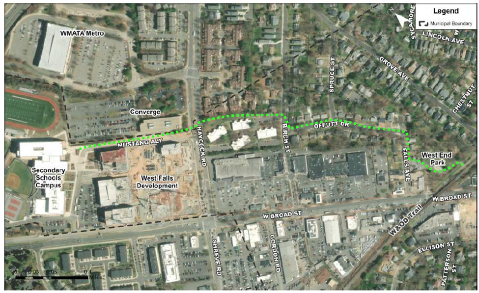
West End Park to Falls Avenue
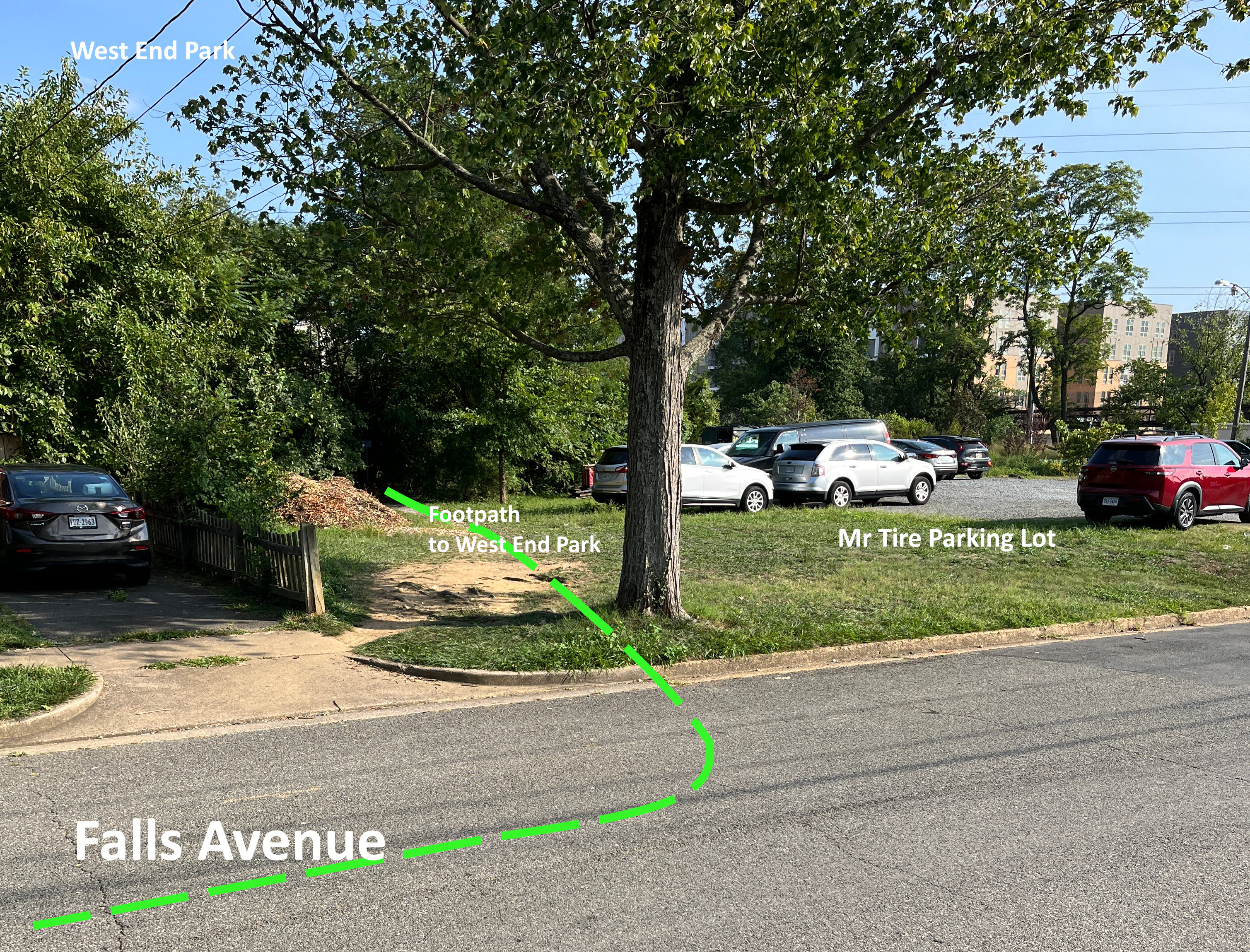
The W&OD Trail passes by West End Park to the east. There is a path from here to the west side of the park where a worn footpath cuts through the Mr. Tire property parking lot, owned by BXA, LLC. Negotiations would be required to permit this use of the land as it is private property.
Falls Avenue to Offutt Drive to Birch Street
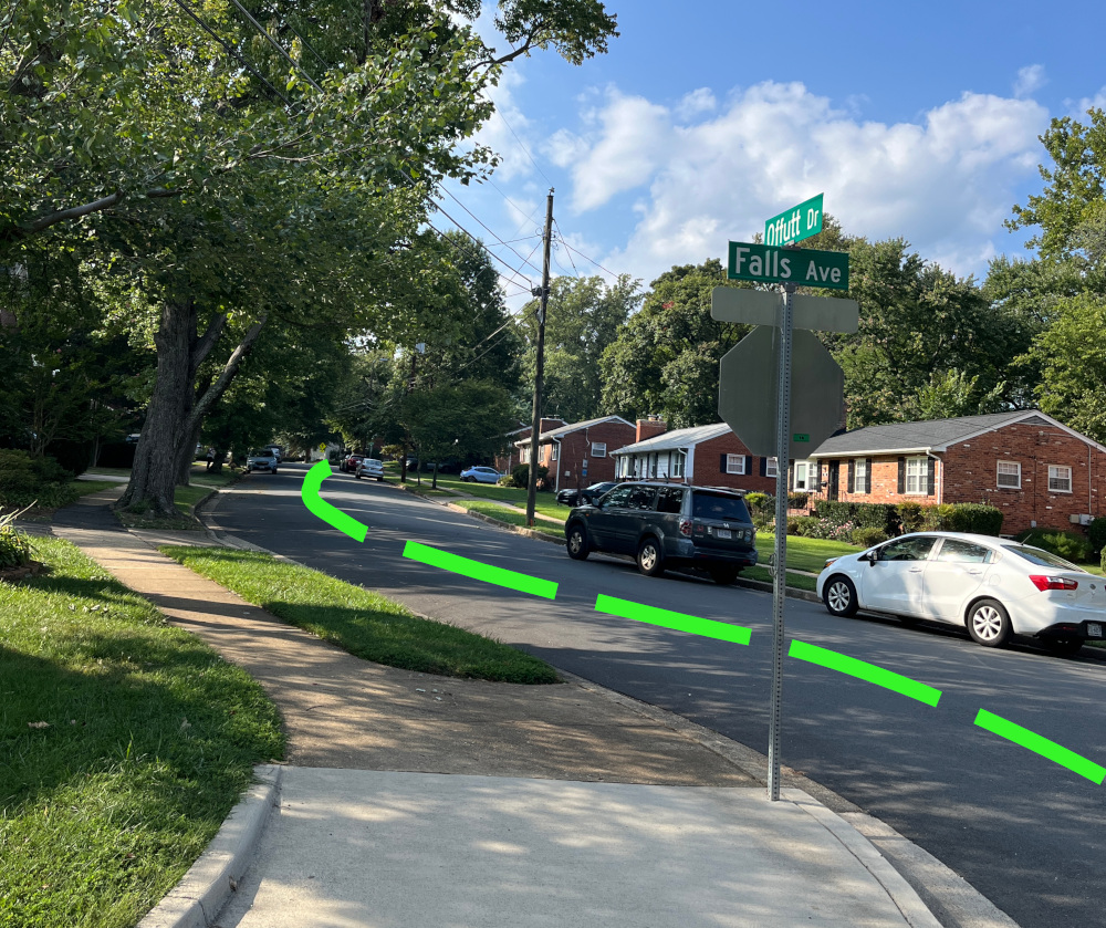
The proposal is to add sharrows and signs on Falls Avenue and Offutt Drive. Both streets are quiet streets with sidewalks on both sides. Parking and travel lanes are to be maintained.
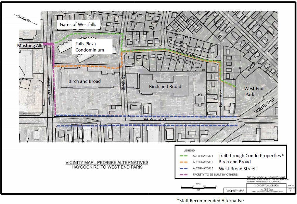
Path between condominiums from Birch Street to Haycock Road
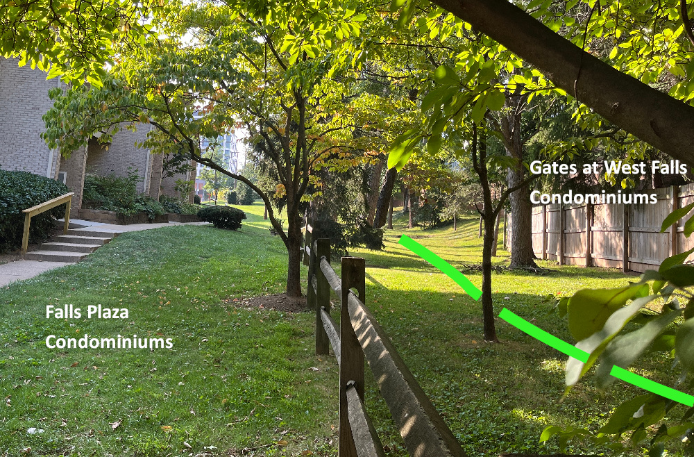
The Rossi study identified a grassy and wooded area with several mature trees between the Falls Plaza Condominiums on one side and the Gates at West Falls and a house (1026 Birch St) on the other. That strip of land runs between Birch Street and Haycock Avenue and can provide the final connection between Birch Street and Haycock Road. Storm drains and utility lines currently run through this strip of land.
Residents at the Falls Plaza say kids currently ride through that area and through the parking lot to travel between Birch Street and Haycock Road.
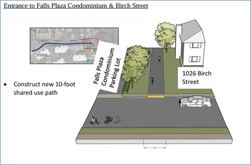
The City would have to work with the two Homeowners Associations (HOAs) and the homeowner to acquire right-of-way or an easement for bike use of this area. City staff proposed constructing a 10-foot wide shared use path on this land, stretching from Birch Street to Haycock Road. City Manager Wyatt Shields said that the City has initiated preliminary conversations with the HOAs and the initial feedback was positive, but that it would take time for both sides to come to an agreement.
Public comments on the East-West connection
Residents of Falls Plaza expressed concern about this section of the route, its safety,impact on privacy, potential for trespassing, and continued health of the existing mature trees. City staff responded that they have spoken with the HOA of the Gates at West Falls about locating the path primarily on the adjacent property owned by the Gates at West Falls, outside of their high fence. The City would install the path using techniques that would limit the impact on trees and evaulate installing fencing and shrubbery to screen the Falls Plaza property.
2. Update on the design for N West Street to Fairfax County line
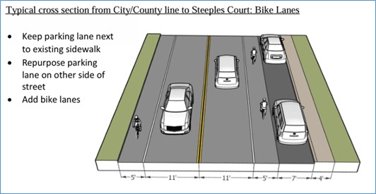
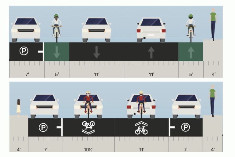
The current proposal would repurpose parking on one side of N West Street to allow bike lanes from Steeples Court to the City/County line. A parking study will be performed, and staff will work with residents to determine where parking will be maintained.
N West Street from Broad Street to Steeples Court would have sharrows added. No changes will be made to the travel lanes.
3. Update on the design for S West Street to Fairfax County line
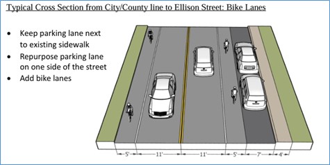
No changes will be made to the travel lanes on S West Street south of Broad Street to Ellison Street. Sharrows will be added to indicate shared usage.
However, from Ellison Street southwards to the City/County line, parking on one side of the street will be repurposed for bike lanes as shown below. A parking study will be performed, and staff will work with residents to determine where parking will be maintained.
Public comments on the West Street routes
Homeowners living along N and S West Street expressed concern about the loss of parking. Staff have agreed to do a parking study and a block-by-block analysis of the parking situation.
Comments were also made about the lack of a sidewalk on one side of West Street, asking the City to consider the needs of pedestrians, too.
People wrote to say that raised crosswalks and speed humps were not bicycle-friendly while others wanted more speed humps to slow traffic.
Staff also received many suggestions on how these and other bicycle routes could be improved.
Projected costs
High-level estimates were provided by staff to implement the three bicycle routes as proposed. (Note that many City infrastructure projects received state and federal funding in the past.) The estimates are divided into three phases:
- Design – developing the plan for construction
- Bicycle Facilities – can include striping and signage and trail construction
- Traffic Calming & Pedestrian Access – can include Americans with Disability Act (ADA) upgrades, new crosswalks, speed humps, and other traffic calming features
Update on the Capital Bikeshare Expansion (Phase II)
The City received a federal grant from the Regional Surface Transportation Program (RSTP) to add Capital Bikeshare stations in multiple locations. Using this grant, $250,000 has been appropriated for FY 2025 (current budget year) and $231,000 for the next year in the adopted FY 2025-2030 Capital Improvements Program (CIP).
Station installations are already planned for the West Falls and Founders Row developments. The BMP update adds four more locations:
- Park Place, near the State Theatre and the Broad and Washington development
- Birch & Broad Shopping Center
- Hillwood Avenue, near Tower Square Shopping Center (Aldi’s)
- S Oak Street, near Fellows Court
Bikeshare operating costs
The annual operating cost of each additional 12-dock Capital Bikeshare station is approximately $14,834.88 per station. The annual operating cost for each additional 15-dock station is approximately $18,543.60 per station. The City has negotiated voluntary concessions from some recent development projects to provide funding toward the annual operating costs for some of these stations. They include:
- West Falls – installation and annual operating cost of the bikeshare station here.
- Quinn – City has the option of $40,000 total or $4,000/year for 10 years.
- Founders Row – annual cost of the bikeshare station here.
- Founders Row II – annual operating cost up to $20,000 (3% annual increase) for the bikeshare station here.
- Broad and Washington – annual operating cost up to $20,000 for the bikeshare station here.
References (not all will be included in post)
- August 5, 2024, City Council meeting. YouTube video.
- August 5, 2024, City Council meeting. Official video. This video will not display properly on a small screen as it includes the agenda.
- August 21, 2024, CACT meeting. This video will not display properly on a small screen as it includes the agenda.
- Bicycle Master Plan Update Staff Report, August 5, 2024.
- Draft Bicycle Master Plan (Clean)
- Bicycle Master Plan Update Existing Conditions Memo
- Bicycle Master Plan Update Public Engagement Report
- East-West Pedestrian/Bike Connection Study, Rossi Transportation Group, Inc., June 2024.
- Public Comments