Falls Church History – The Water Wars and the 2013 City/County Boundary Adjustment That Facilitates Development Of City-Owned Land
Summary
The West Falls Economic Development and ongoing plans to modernize the City’s Property Yard facilities on Gordon Road ultimately benefit from the boundary adjustments with Fairfax County involving City-owned land that were completed in 2013. Oversight for these plans and any economic development on this land now resides with the City, as will the tax revenues.
To provide an historical overview, we look back at the Water Wars between Falls Church and Fairfax County and the resulting transactions with the County to document how City plans for the land in the Gordon Road Triangle and West Falls have advanced.
The Water Wars
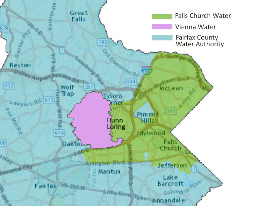
By the mid-2000s, Falls Church Water served a 33-square mile area that, in addition to the City, included McLean, Pimmit Hills, Merrifield, and Falls Church in Fairfax County. 92% of its customers were in Fairfax County. Each year, some of the proceeds from Falls Church Water were transferred to the City’s General Fund to support the City budget, considered the City’s return on equity, and later its “management fee,” reflecting the risk and expense of providing the service.
In 1959, the City and Fairfax County signed an agreement that defined the area of Fairfax County that would be served by Falls Church Water, but this agreement was not extended after it expired in 1989. The trouble between Falls Church City and Fairfax County over who had the right to supply water to Fairfax County customers came to a head when the County cut deals with developers near the Dunn Loring Metro Station to supply their water.
A series of lawsuits
In February 2007, Falls Church sued Fairfax County in Federal court, claiming that the City had an exclusive right to serve that Dunn Loring part of Fairfax County. The Federal court rejected this claim, and that decision was affirmed on appeal.
In December 2008, Fairfax County filed a lawsuit in state court, accusing the City of violating the Virginia Antitrust Act and asking the judge to end the City’s practice of transferring the utility’s excess funds to the City’s General Fund. In 2010, Judge R. Terrence Ney ruled in favor of Fairfax County, stating that, “… transferring of the profits derived from the sale of water and related service into [the City’s] General Fund amounts to an unconstitutionally void tax on non-residents of the City.”
Judge Ney’s opinion included data regarding the size of the transfers: “The annual profit from 1985 to 1998 ranges from $1 million to $1.6 million per year. These sums doubled and tripled from 1999 to 2002, totaling nearly $4.9 million in 2002. Since 1999 the profit transfers have averaged about $2.3 million per year.” The City’s total revenues were $38 million in 1999 and rose to $62 million in 2008. The City was also required to return the transfers from FY 2009 and FY 2010 to the utility.
The City appealed the ruling to the Virginia Supreme Court and lost. The judgement could not have come at a worse time. The City, like other jurisdictions, was dealing with the impacts of the Great Recession that began in 2008. A steep rise in taxes for City property owners resulted both from the financial crisis and to make up for the loss of revenues from the water utility. The tax rate climbed from $1.07 to $1.24 from 2009 to 2010.
Events leading to the sale of the City water system and the change in boundaries
In 2011, Fairfax County passed an ordinance that required all new water hookups in Fairfax County to be with Fairfax County Water Authority (FCWA). In 2012, Fairfax passed another ordinance that set the water rates for the entire county, more than a third below Falls Church Water’s rates. The City decided to sell the water utility that year.
There were nine potential bidders for Falls Church Water, FCWA being one. But the US Army Corps of Engineers, which supplied the water to the utility, said that it could only service a government-owned water distribution system. FCWA was the only such bidder.
Terms of the sale of Falls Church Water to Fairfax County Water Authority
Falls Church and Fairfax County agreed to mediation led by a Federal judge. In November 2012, that mediation successfully concluded. The City’s 2012 Financial Report outlines the terms of sale of the Falls Church water system, including:
- Fairfax Water will purchase the Falls Church water system assets for $40 million. The city will retain debt and pension obligations of the water system of about $30 million. The City’s water utility assets, including three undeveloped land parcels located in Fairfax County totaling approximately 9 acres, will convey to Fairfax Water.
- Approximately $26 million in availability fees, currently in the water fund, designated to be used for the expansion of the water system, will convey to Fairfax Water.
- Within two years from the sale closing, Fairfax Water will reduce the water rates to all customers in the City’s service area to Fairfax Water’s rates and will thereafter maintain a uniform rate for all customers, barring any extraordinary utility requirements.
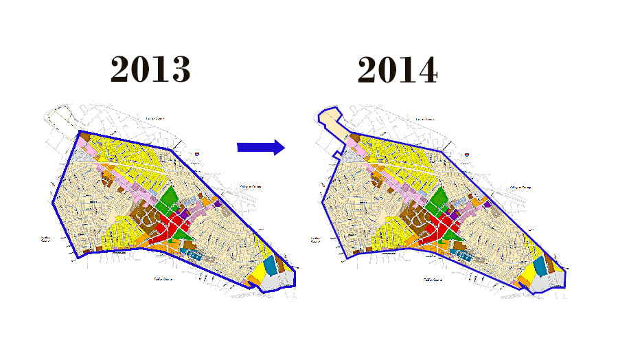
- The City’s boundary with Fairfax County will be adjusted … The land transfer amounts to approximately 42 acres.
Voters approved the agreement through a referendum
Falls Church voters approved the sale of the water system in a public referendum on November 5, 2013. The referendum asked, “Shall the City of Falls Church sell its water system to the Fairfax County Water Authority for consideration including a payment to the City of $40 million, and a boundary adjustment that will bring within the City’s boundaries the George Mason High School and Mary Ellen Henderson Middle School properties, certain City-owned properties on Gordon Road and Shreve Road, and certain other properties?” The referendum passed with 4,149 Yes votes and 569 No votes.
On Friday, January 3, 2014, the sale of Falls Church Water for $40 million was made official. As documented in City Resolution 2013-41, a total of $19 million of the proceeds were used to pay the existing debt of the water system, a portion used to cover water employee pension obligations, yielding net proceeds of $14 million and “put to use exclusively for the broad public interest and benefit of City taxpayers.” City Mayor Nader Baroukh said at the time, “The sale of the water system is a win-win situation for the City, the County, water customers, and water employees.”
A very readable and detailed account of the water wars history can be found on Charlie Grymes’ website, VirginiaPlaces.org.
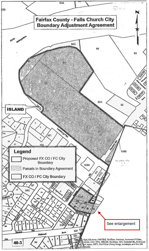
The Voluntary Boundary Adjustment Agreement
In December 2013, the City entered into a Voluntary Jurisdictional Boundary Adjustment Agreement (boundary agreement) with Fairfax County to adjust jurisdictional boundaries to add two groups of properties into the City, referenced as the “School-related parcels” and “Additional parcels”. The school-related parcels were three separate parcels totaling approximately 34.6 acres and owned by the Falls Church School Board and the City. The additional parcels comprised 11 different parcels along Haycock Road (Route 703) and Gordon Road totaling approximately 3.8 acres. Of those additional parcels, the City of Falls Church owns approximately 2.4 acres that are currently occupied by the City’s Property Yard and maintenance facilities.
The boundary agreement acknowledged the “desire to facilitate and effectuate this acquisition [of the water system by Fairfax Water], through mutual agreement, by making certain changes to the boundary lines between Falls Church and the County…”
The School-related parcels and a limitation imposed
The school-related parcels included the following:
- Parcel 91, approximately 8.36815 acres owned by the City of Falls Church;
- Parcel 93, approximately 1.59753 acres owned by the City of Falls Church; and
- Parcel 94, approximately 24.65471 acres owned by the School Board of the City of Falls Church; except for a small island of land completely surrounded by Washington Metropolitan Transit Authority (WMATA) right-of-way along Leesburg Pike near the Mary Ellen Henderson Middle School parking lot.
Fairfax County placed a limitation on the school-related parcels. At least 70% of the acreage can only be used for “school purposes” for 50 years, after which it may be used for any lawful purposes. Up to 30% of the acreage may be used immediately for any lawful purposes. In 2019, the City leased this land to create the West Falls development in a public-private partnership to help pay for the new Meridian High School.
An article in the November 28, 2012, issue of the Falls Church News-Press reported that it “learned from a separate source Fairfax had adopted a rigid posture of refusing any uses other than education for the 39.5-acre land parcel [SIC] that Falls Church wanted brought within its borders that is currently home to George Mason High School and Henderson Middle School.” (FCNP, November 28, 2012).
Additional parcels along Haycock Road near the school-related parcels included:
- Parcel 109A, approximately 0.61619 acres owned by Trustees for Federal Realty Investment Trust;
- Parcel 109B, approximately 0.00124 acres owned by Federal Realty Investment Trust; and
- The entire width of the Haycock Road right-of-way that runs parallel to Parcel 94, approximately 0.77418 acres.
The Gordon Road area
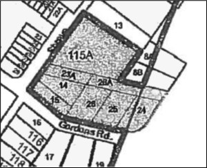
Additional parcels in the Gordon Road area owned by the City included:
- Parcel 14 and 15, together approximately 0.38762 acres;
- Parcel 23A, approximately 0.14839 acres;
- Parcel 24, approximately 0.09554 acres;
- Parcel 25, approximately 0.28168 acres;
- Parcel 26, approximately 0.30463 acres;
- Parcel 26A, approximately 0.17932 acres; and
- Parcel 115A, approximately 1.00048 acres
The City is planning to upgrade the Property Yard in this area in such a way as to allow further economic re-development. [Read Property Yard Design Concepts Report Released.]
On an historical note, the unusual narrow and diagonal parcels 23A and 26A indicate the former Washington, Arlington & Falls Church Railway right-of-way that followed the trolley’s route toward Dunn Loring and Vienna.
Virginia Tech graduate campus is not included
The site of Virginia Tech’s Northern Virginia Center (NVC) comprising two parcels owned by the City at the time, parcels 92 and 92A, were excluded from the boundary adjustment due to prior agreements relating to the NVC site. These parcels remain under Fairfax County’s jurisdiction. Similarly, there are numerous parcels totaling approximately 5 acres along the eastern side of Shreve Road (adjacent to the City-owned property) that remain in Fairfax County.
Sealing the Voluntary Boundary Adjustment Agreement
In May 2013, Falls Church and Fairfax County formally submitted to the Commission on Local Government a request to review the proposed voluntary settlement agreement negotiated by the two jurisdictions under the authority of Section 15.2‐3400 of the Code of Virginia. On July 8, 2013, the Commission toured relevant sections of the City of Falls Church and Fairfax County and received oral testimony from the two jurisdictions in support of the agreement. That evening, the Commission held a public hearing, to receive citizen comment. The public hearing was attended by approximately 19 people, and three individuals testified.
The Commissioners summarized their findings in a report dated September 2013, and concluded “we find that the agreement promotes the viability of both local governments and is consistent with the best interests of the Commonwealth. Accordingly, we recommend the court’s approval of the agreement.”
The end of the Water Wars and new boundaries for Falls Church
The Commission report also acknowledged that in 2012, “the City filed suit against Fairfax County challenging an ordinance the County passed attempting to set water rates charged by the City to County residents, and to control future expansion of the City’s water utility in the County.“ As part of the court settlement, the lawsuit against Fairfax County was dropped (thus ending the legal battle), with the City agreeing to sell the entire water system to FCWA and begin negotiations that led to the boundary agreement.
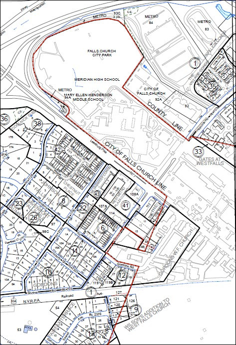
(Boundary enhanced in red to clarify)
References
- “It’s Official: Fairfax Water Purchases Falls Church Water System for $40 Million”, Falls Church Patch January 3, 2014
- Voluntary Boundary Adjustment Agreement By and Between the City of Falls Church, Virginia and Fairfax County, Virginia, December 11, 2013
- City Council Resolution 2013-41: Resolution Expressing The Goals Of The City Council For The Use Of Water Sale Proceeds; Adopted December 9, 2013
- Report On The City Of Falls Church – County Of Fairfax Voluntary Settlement Agreement , Commission on Local Government Commonwealth of Virginia, September 2013
- Shields Credits Mediator With Big Role Making Water Deal Happen, Falls Church News-Press, November 28,2012
- Blockbuster Water-for-Land Swap Agreed to by Fairfax, Falls Church, Falls Church News-Press, November 21,2012
- Fairfax County Water Authority v. City of Falls Church, Law No. 2008-16114, Opinion letter by Judge R. Terrence Ney, January 6, 2010. This document is available from the Mary Riley Styles Library Falls Church History Room.
- Fiscal Year 2012 Annual Financial Report, City of Falls Church.