Land Use, Rezoning, and the City’s Plans – A Framework for Considering New Townhomes on S Lee Street
By Mary Chaves
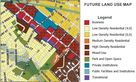
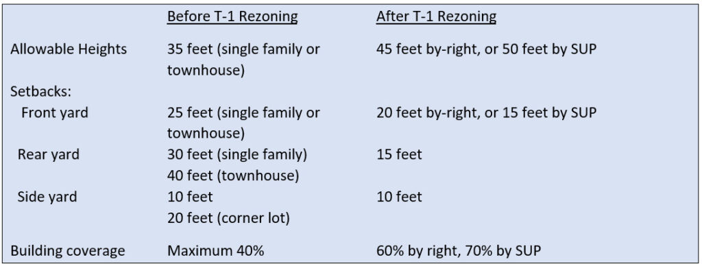
(Above: Future Land Use Map, City of Falls Church, June 2024.)
Summary
- Falls Church has a framework for considering future development, based on key elements of the City’s Comprehensive Plan, its Future Land Use Map, and Small Area Plans written for select sections of the City.
- Madison Homes’ rezoning request and proposal for new townhomes on S Lee Street will need to be reviewed under these guidelines, as well as the relevance of the new T-1 zoning passed in late 2023 that substantially changed what were transition lots at the time of the 2005 Comprehensive Plan and the 2016 West Broad Small Area Plan.
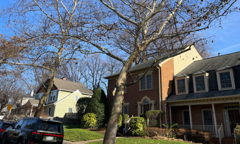
- The S Lee Street neighbors have written to the City Council and the Planning Commission regarding their concerns about proximity as well as additional impacts on stormwater and sewer capacity, parking, and traffic.
- Did the City’s planners intend for such redevelopment on Broad Street, or “infill”, in residential neighborhoods?
Background
Falls Church City’s Comprehensive Plan provides policy guidance for future land use and development within the City. As indicated in the City’s 2005 Comprehensive Plan:
“A comprehensive plan for a jurisdiction generally includes an official map of future recommended land uses in addition to a set of goals, policies, and/or a “vision”, which serves as a guide for a community’s future.”
The history of the City’s vision for the area including S Lee Street goes back to the 2005 Comprehensive Plan, its designated Planning Opportunity Areas (POAs), the Plan’s Future Land Use Map, and the 2016 West Broad Street Small Area Plan.
The City Council and the Planning Commission are now in very early stages of considering the future revision of Comprehensive Plan Chapter 4: Land Use and Economic Development, which contains the guts of planning goals for the City’s future development and hasn’t been updated since 2005. While the Future Land Use Map has been updated regularly with new developments, the 2024 version reflects the basic structure of that adopted in 2005 with several modifications for new mixed-use and other developments.
Planning Opportunity Areas
As summarized in the Virginia Tech 2022 study on the 2005 Comprehensive Plan:
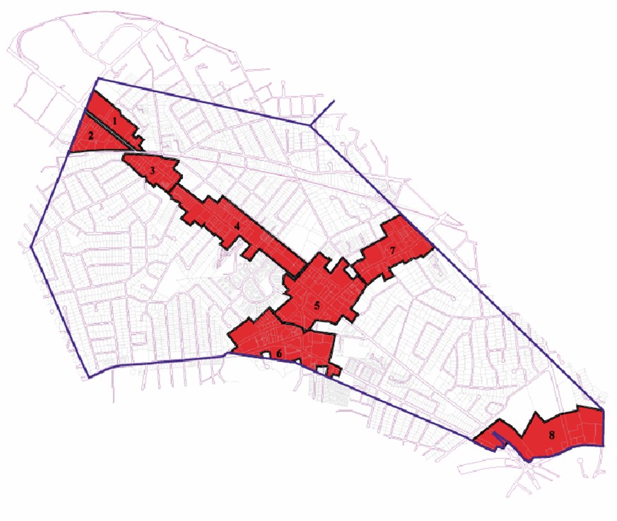
“The 2005 Comprehensive Plan designated Planning Opportunity Areas (POAs)—commercial areas of about 10 blocks in size where redevelopment might occur along Broad Street (Route 7) and Washington Street (Route 29). These areas contain a substantial number of underutilized properties where additional development or redevelopment might occur. These areas offer opportunities for the City to increase its tax revenue in both the short and long term.” (p. 7)
The 2005 Comprehensive Plan referred to the area from Little Falls to approximately Spring Street along Broad as Planning Opportunity Area # 4, or “The Village Section”. The Broadway condominiums, bordering N Lee Street, were completed as a new mixed-use development in this area in 2004, with the prospective Byron and Spectrum condominium buildings reaching completion in 2006 and 2008, respectively. Mixed-use and business land use categories were recommended for the Village Section to achieve a mixture of residential, office, and low-intensity commercial uses, including the consolidation of small lots in certain locations along Broad.
The Future Land Use Map intended to allow consolidation with Broad Street lots
The Future Land Use Map adopted in 2005 foresaw the potential for future conversion of the two R-1A residential lots at 106 and 108 S Lee Street to transition use to facilitate such development, given the very narrow width of land available for commercial purposes in that area.
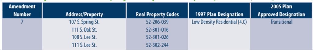
The area between S Lee and S Oak bordering Broad Street and including two residential lots on each street was a particular area envisioned as a “potential redevelopment site.” 106 S Lee had apparently been included in the 1997 Comprehensive Plan as a potential future transition lot, while 108 S Lee, 111 S Lee, 111 S Oak, and 107 S Spring were newly added in 2005 to the Future Land Use Map as potential future transition lots in order to “promote new development or redevelopment and move the City closer to its vision for the future.”
The West Broad Street Small Area Plan describes the 2005 Land Use Plan as the basic document that has been amended over time based on subsequent developments:
“The Future Land Use Map is an official policy document and an element of the City’s Comprehensive Plan. The Map shows the preferred uses of different areas in the City. Future Land Use Maps are more general than a zoning ordinance. Where a zoning ordinance includes legal definitions, a land use map includes concepts. The Map was last reviewed comprehensively with the 2005 Comprehensive Plan. Since then, the Map has been amended from time to time as part of the redevelopment process.”
West Broad Street Small Area Plan to encourage Broad Street commercial redevelopment
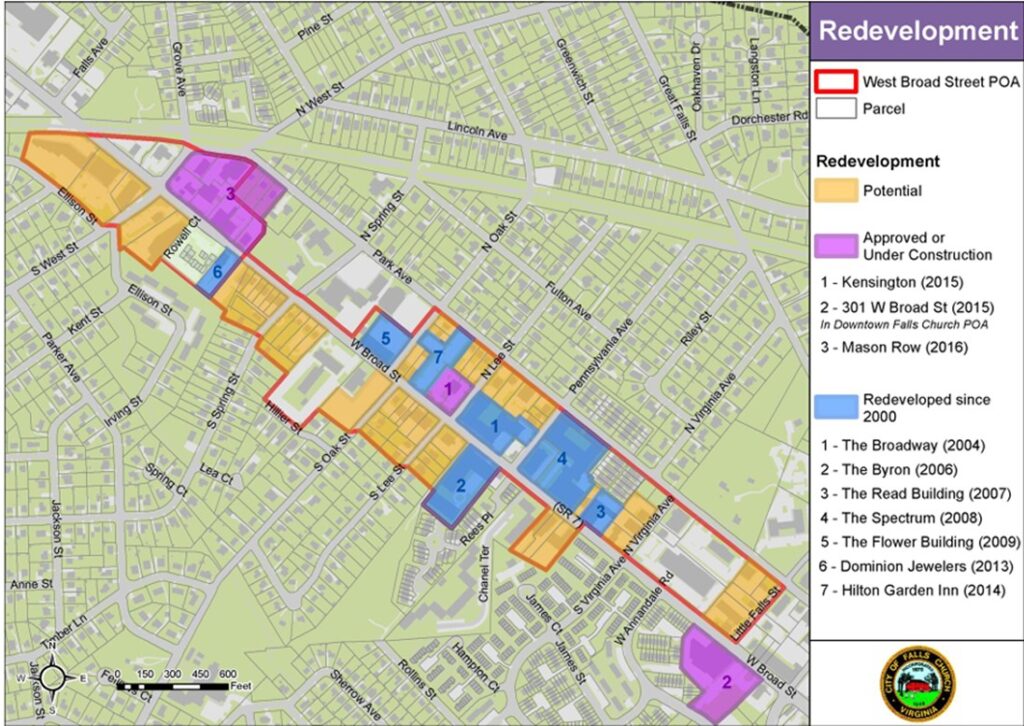
Starting in 2012 with the N Washington Street Planning Opportunity Area, the City under former Community Planning and Economic Development Services Director Jim Snyder’s guidance began developing Small Area Plans (SAPs) for each POA to help guide land use changes over time.
The West Broad Small Area Plan, adopted in 2016, was intended to be a conceptual framework for redevelopment and public improvements within the West Broad Street (formerly #4 Village Section) POA. As indicated in its introduction:
“The recommendations in this Plan are meant to provide a starting point for public and private investment into general improvements to the area. This Plan does not constitute a change to the City’s Comprehensive Plan, Future Land Use Map, Zoning Ordinance, or Zoning Map.”
The SAP acknowledged the successful private consolidation of lots along the north side of West Broad for the Hilton Garden Inn, the Flower Building, the Broadway, Founders Row, and the Kensington. It noted: “Developer interest is still strong enough to merit consolidation of smaller parcels even though many of the larger parcels have already been utilized for redevelopment.” The Plan noted, in particular, the potential for future consolidation of the properties along the south side of Broad Street between S Lee and S Oak Streets, including the neighboring residential lots.
The 2022 Virginia Tech study summarizes the objectives laid out in the 2016 West Broad Street Small Area Plan:
“The vision and goals of the West Broad Small Area Plan call for developing an office and hotel node and retail nodes, as well as incorporating more mixed-use development. The land use chapter identifies 21.5 acres within the West Broad Street POA as having the potential for immediate redevelopment.” (p. 8)
For future projects, changes in land use would be determined on a case-by-case basis, following recommendations from the Planning Commission, opportunity for public comment, and approval by City Council.
Impact on adjacent neighborhoods
The West Broad Street Small Area Plan indicates that any redevelopment to the south of Broad Street will have to be compatible with surrounding neighborhoods. “Compatible” has a history in Falls Church, emphasizing the importance of transitioning to (and buffering) residential neighbors, both next door and across the street. Founders Row, Founders Row II, and Northgate mixed-use projects made a decided effort to reduce heights at the edge of the projects to the 35-foot level of those of adjoining residential homes and those across the street. The Broad and Washington development also reached agreement with the adjacent residential owners on reduced heights and expanded 40-foot setbacks from the property line as it surrounded that property on two sides.
The S Lee Street neighbors have written to the City Council and the Planning Commission regarding their concerns about proximity as well as additional impacts on stormwater and sewer capacity, parking, and traffic as summarized here. [See the Pulse post, Proposed Rezoning at 106-108 S Lee Street to T Zone Sparks Community Concerns, May 8, 2025.]
The T-Zone code revision greatly increased the value of T-1 lots
The 2023 revision of the transition zone ordinance greatly increased the value of T-1 lots. The late developer Robert Young purchased two lots totaling 0.36 acres at the corner of N Oak Street and Park Avenue in June 2021 for $1.725 million, just before formal discussions on revising the T Zone code began. (Mr. Young was chair of the Economic Development Authority at the time.) The lots were sold to Madison Homes for $3 million to build 12 townhomes in July 2024. Mr. Young also bought 106 S Lee Street, a potential future T-1 lot, in February 2022, for $1 million. Madison Homes plans to finalize its purchase of this lot for an undisclosed amount if the City approves its rezoning from R1-A to T-1.
Pirouz Khanmalek, owner of Espinzar, LLC and a member of the City’s Architectural Advisory Board, owned two lots totaling 0.69 acres at the corner of Park Avenue and N Lee Street, which he purchased in 2006. These properties were assessed at $2.2 million in 2024 and were sold to Madison Homes for $8.25 million in October 2024.
Rezoning to the new T-1 (transition) lots
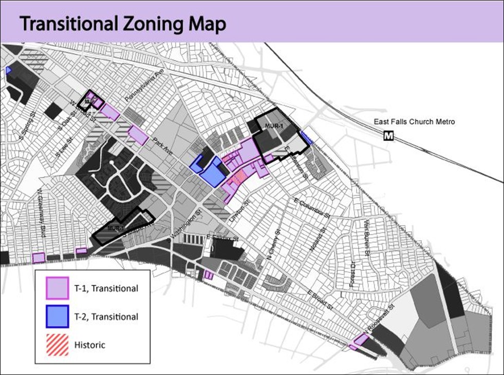
The City’s decision in September 2023 to rezone historical transition zones to facilitate infill development, particularly along Park Avenue, has substantially changed what were transition lots in 2005 or 2016 at the time of the 2005 Comprehensive Plan and West Broad Small Area Plan. Expectations for City planners at those times would have been quite different from what the new regulations for T-1 lots would allow. The changes for transition lots included (among several other specific provisions):
What about the City’s intent in allowing rezoning?
Madison Homes is assuming that the future land use designation of potential future transition lots on S Lee means that it can develop 45-foot townhomes on these lots with all the new by-right privileges provided by the recent rezoning. This would require both a Comprehensive Plan amendment and a rezoning to be approved by City Council.
However, it is questionable whether that was the City’s prior intent:
- The 2005 Comprehensive Plan and the 2016 Small Area Plan explicitly endorsed the potential future conversion of these lots to transitional properties on the assumption that the lots would facilitate consolidation and redevelopment of the property on Broad Street. That is not the case here. Indeed, conversion to T-1 properties for the purpose of building 4-story townhouses would clearly undercut any future prospects for development of the lot fronting Broad Street.
- The City’s discussion of rezoning transition lots to facilitate “infill” development along Park, N Washington, S Washington, and S Roosevelt Streets made no mention of potential future conversions to T-1 properties. In fact, the City’s map of relevant transition lots for the rezoning explicitly excluded them. Assuming a further expansion of T-Zone lots under the new provisions would not be consistent with the community understanding of the action taken and could diminish public trust.
- The newly rezoned T-1 lots were never intended to be “infill” in residential neighborhoods; projects approved to date have not adjoined low-density residential lots.
References
- 2005 Comprehensive Plan, Chapter Four, Land Use and Economic Development.
- Falls Church West Broad Small Area Plan – Connecting Falls Church, Adopted April 11, 2016.
- Proposed T-Zone Updates/Falls Church, VA Official Website.
- City Council Meeting Agenda, Staff Report on T-1 Rezoning, for September 26, 2023.
- Falls Church Current Development Projects, 106 and 108 S. Lee Rezoning.
- Letter from Andrew Painter to Akida Rouzi, Zoning Administrator, for a Conditional Rezoning, March 4, 2025.