The Greening of Lincoln Cost Estimate Balloons to $20 million
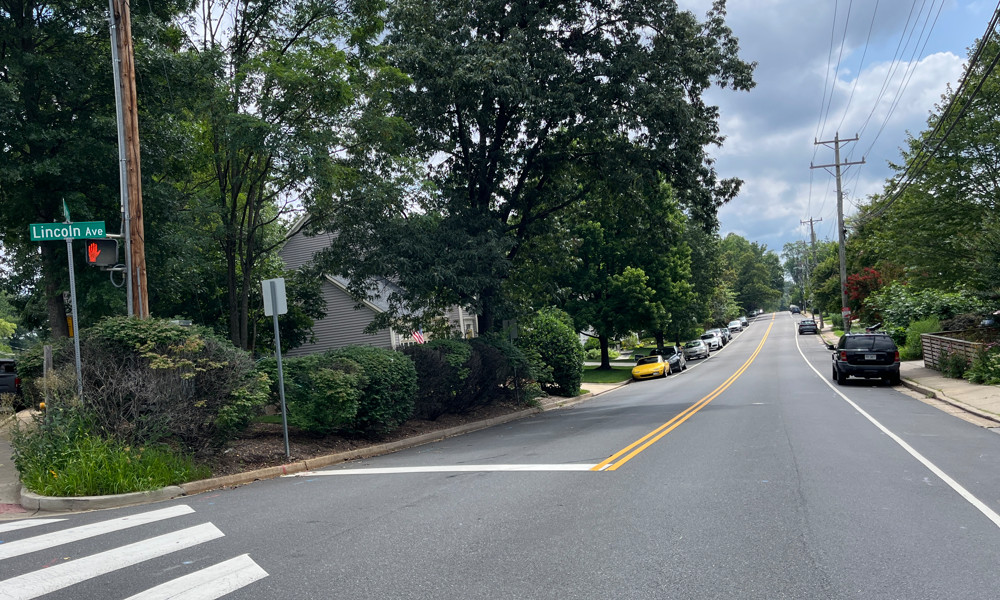
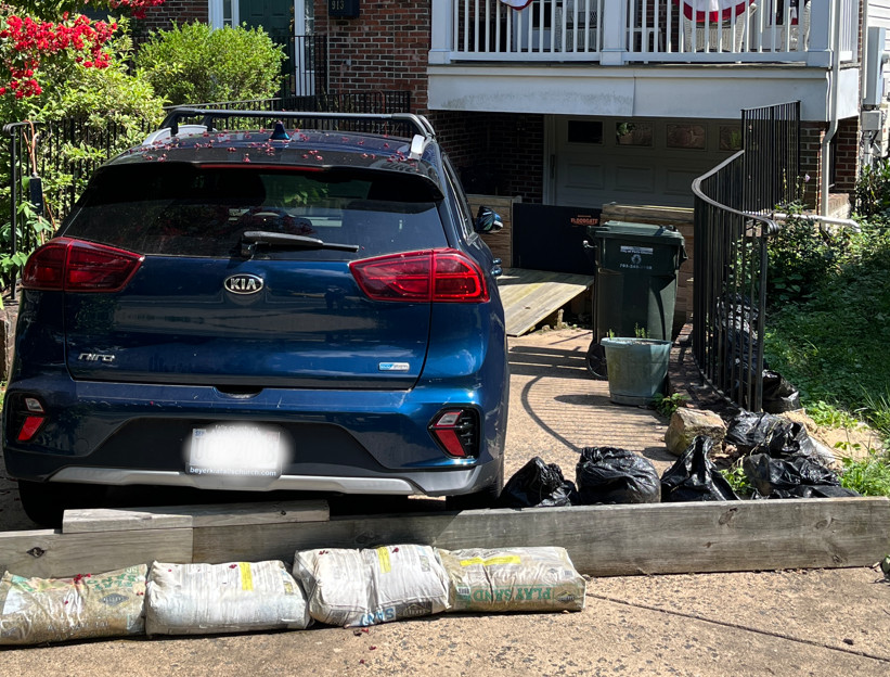
(Photo: Lincoln Avenue at West Street, July 2025.)
Summary
The cost estimate for the Greening of Lincoln (GOL) project was originally $8 million, then budgeted for $11 million, but now expected to be $20 million because of the condition of the road subbase and increased construction costs blamed on tariffs.
The Public Works team divided the project into four phases, the first two will be completed in 2026 with the budgeted funds. The remaining two phases will be shelved until funds are available.
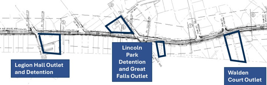
Phase A is the installation of stormwater retention infrastructure at Lincoln Park, the American Legion property and around Walden Court.
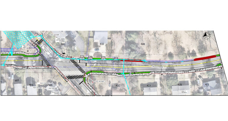
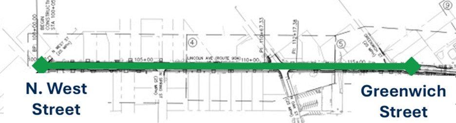
Phase B is to implement the GOL design on the section of Lincoln Avenue from West Street to just past Greenwich Street.
Background
The Greening of Lincoln (GOL) project is a stormwater and road infrastructure project that completely redesigns most of Lincoln Avenue, from Arlington to N West St, taking advantage of the scheduled rebuilding of the road subbase and preexisting City-wide plans for stormwater mitigation (the Big Six[EH1] ). The project’s goals are to address the property flooding issues along this roadway, and the road safety issues due to heavier and often dangerously fast traffic.
The initial introduction of the project (15% design plan) and neighborhood response is covered in the Pulse post The Greening of Lincoln – A Stormwater Project, [January 28, 2024] . Following many community meetings, a final concept plan was produced and summarized in The Greening of Lincoln Avenue Final Concept Plan Is Ready, [July 23, 2024].
The 60% design plan for the GOL project was made available to the public in May 2025, and resulted in further comments from the community. The Public Works staff provided the City Council an update at its July 7, 2025, work session.
Note: Public Works projects do not require formal approval from the City Council or Planning Commission. However, both bodies are typically briefed on larger projects. The City Council’s role is to approve the funding for projects during budget discussions and when contracts are awarded to consultants and outside contractors.
$20 million cost more than double the original cost estimate
When the project was first presented to the City Council in January, 2024, the cost estimate of $8 million was to be covered by the American Rescue Plan Act (ARPA) and state grants for $7.5 million, with the City paying only $0.5 million. By September 2024, staff returned to the Council with a cost estimate of $11 million.
The latest cost estimate is $20 million, far exceeding the built-in contingencies in previous estimates. Staff reported that “This increase is due to two primary factors:
- Deteriorated Road Subbase: Field assessments revealed that more extensive roadway subbase replacement is required than originally anticipated.
- Rising Construction Costs and Market Volatility: Project cost estimates account for escalating unit prices in the current market. In addition, continued market uncertainty requires increased contingency funds.”
Council Member Erin Flynn asked for a more detailed breakdown of the cost increase. Her concern was that the City’s paving schedule has been slower than necessary for the expected life of the roads since the Great Recession. She was concerned whether that was going to end up costing the City more money in the long run. Staff did not immediately have that information.
A phased construction
The City’s new Public Works Director Amanda Stout Brain presented a plan to focus on two sections of the design that uses the funds and grants already allocated. The remainder of the project will be delayed until additional funding can be found.
The two sections are:
- Phase A – Stormwater detention infrastructure and major outlets, funded by $4 million in ARPA funds.
- Phase B – Full design implementation from West Street to Greenwich Street, funded by $5.1 million in State grants (Virginia Department of Transportation and Stormwater Local Assistance Funds), and $950,000 in local funds budgeted for this project.
Phase A: Priority Stormwater Infrastructure
This green infrastructure satisfies the conditions for using ARPA funds. The 100% design is expected by the end of 2025 to allow construction to start in January 2026 and end in June of that year. The diagram below shows the stormwater infrastructure that will be the focus of this phase.
Details of Phase A:
a. American Legion site
The City has agreed to demolish the house behind the American Legion and install a rain garden style stormwater detention structure on the property, as shown below.
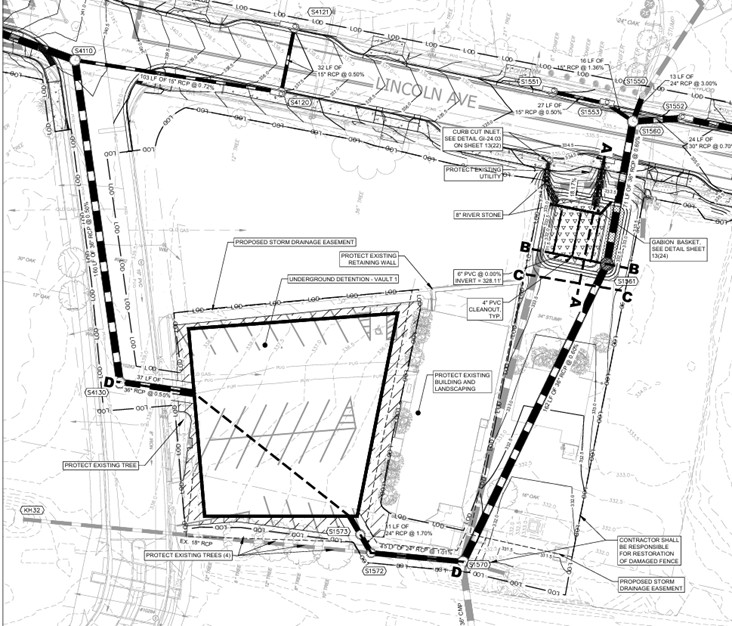
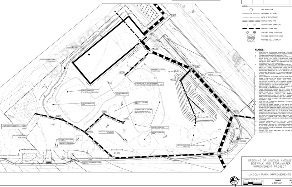
b. Lincoln Park site
An underground vault is to be placed where the basketball court is located. New drainage systems will be installed, including one across the road where the Lincoln Park stormwater pipes drain into low points in Lincoln Park. There is also a rain garden planned near the Great Falls Street fence line. The plans call for retaining the old basketball court equipment for reuse, though details on the surface of the retention basin / basketball court are typically a 90% design item.
c. Walden Court outlet
This replaces the existing, 60+-year-old, 22”x36” corrugated metal stormwater pipes with 45”x29” reinforced concrete pipes near Walden Court.
Phase B: West Street to Greenwich Street
This section was prioritized because of the extensive property damage to homeowners from flood events and because that stormwater work requires significant road work. The 100% design for this section of Lincoln Avenue is scheduled to be completed by June 2026, followed by construction in the second half of that year. The diagram below shows the section of Lincoln Avenue that is included in this phase.
Details of Phase B:
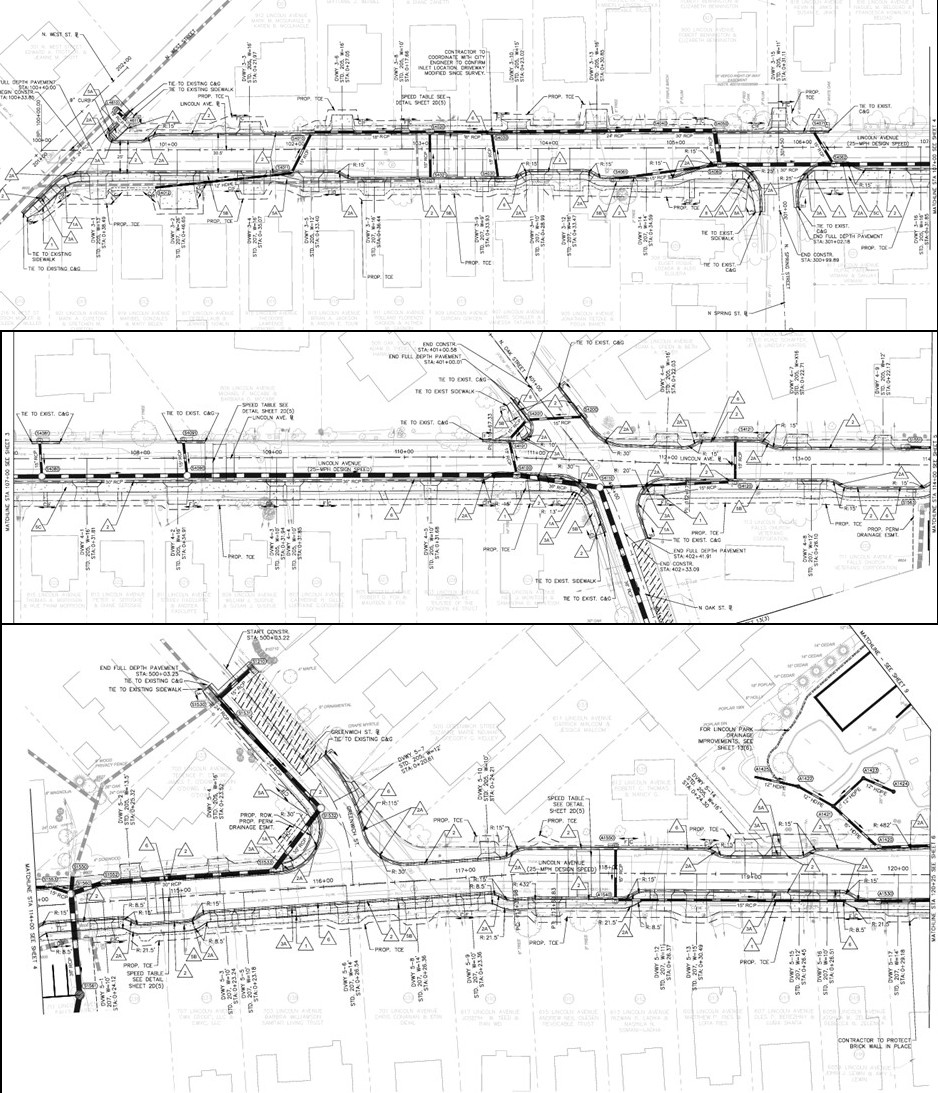
These images from the 60% design show traffic lanes that are 11 feet wide. Staff have agreed to evaluate narrowing the lanes to 10 feet. The full set of drawings, including demolition plans, are available here.
Signage and Road Markings
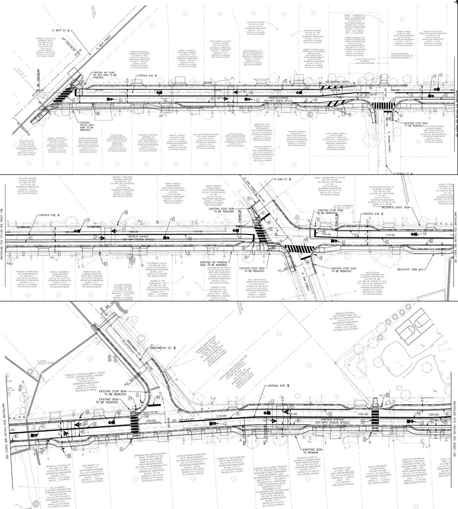
Roadway Plan
When to close public input?
Typically, the public is involved only in the early stages of the design for a project like this—usually up to 30%. However, the Council has asked that staff be flexible on this project to allow input beyond the 60% design. Council Member David Snyder pointed out that even the 60% design has generated good suggestions, such as narrowing the traffic lanes from 11 to 10 feet.
The City contracts out the design of this project to traffic engineers and consultants and relies on them to assess what features and requests are feasible.
Staff noted that they are working with individual homeowners as questions arise about impacts on their property and will share more information about mitigating construction impacts when the plans are more mature and the project is closer to construction.
Narrowing the travel lanes to 10 feet
Lincoln Avenue homeowner Andrew Olesen, writing on behalf of his neighbors, asked for travel lanes to be narrowed from 11 feet to 9-10 feet, based on National Association for City Transportation Officials (NACTO) guidance that 9-10 foot lanes are safest. Mr. Snyder consulted the City Attorney and discovered that the City has control over the design of the streets, except for a few that are under VDOT control. He pointed out that lane narrowing may present opportunities for bike and pedestrian facilities and green space in this and other parts of the City. Most travel lanes in the City are 11-12 feet wide.
The Public Works staff agreed to evaluate narrowing the travel lanes from 11 feet to 10 feet for the entire length of Lincoln Avenue. Lanes on Lincoln Avenue today range from 10.5 feet to 12+ feet wide.
Council Member Justine Underhill asked about narrowing the roads at the intersections as well, and at Oak Street in particular. Project Manager Tony Dudley said the intersection is 25 feet wide on Oak Street and he would need to consult with the engineers about narrowing it. Lincoln Ave, the busier road, would be 22 feet wide if lanes are narrowed (2 x 10-foot lanes + 1-foot gutter by the curb).
Designing for 20 mph instead of 25 mph?
Mayor Letty Hardi asked if there was a typo in the design specifying 25 mph as the speed for Lincoln Avenue instead of 20 mph, the posted speed limit. Mr. Dudley replied that that was intentional as some traffic engineering guidebooks specify choosing a design speed equal to or greater than the speed limit. Ms. Hardi asked if the design could be changed to 20 mph.
Deputy Director of Engineering Tara Hoff explained that the specified speed affects the driver’s sight lines and the sight distance requirements for the design. She explained, “The faster the design speed is, the more distance you need for …pedestrian visibility.” If pedestrian visibility at crosswalks is a concern, then designing for a higher speed would be preferable.
Mr. Olesen shared that this is a topic of evolution within the traffic engineering community. Higher design speeds mean straighter roads and longer sight lines, both of which encourage faster driving, making crashes more severe, especially for pedestrians. Until 2001, it was the requirement to set speed limits at the speed chosen by the third fastest driver in 20 drivers and to set the design speed above that number. NACTO recommends making a target speed, design speed, and speed limit equal (here, 20 mph).
Speed tables, speed humps, and raised crosswalks
The plans call for speed tables (extended “speed humps” with long flat tops typically used on roads with 25-45 mph speed limits) at 906, 806 and 700 Lincoln Avenue, with associated street-side signs. This is a change from the concept plan that proposed raised crosswalks to slow cars at crosswalks and provide more visibility for pedestrians.
Staff’s rationale for this change is that speed humps and raised crosswalks can cause difficulty for snow ploughs and emergency vehicles on this designated snow emergency route. Staff also expressed reservations about placing raised structures where vehicles are turning as they may upset those vehicles.
The consultants have, instead, planned for speed tables that have a more gradual rise and are acceptable to emergency vehicles and snow ploughs. Instead of raised crosswalks, the plans show high visibility crosswalks to be implemented as specified in the recently revised streetscape standards.
The Council and comments from the public noted that speed tables are simply raised crosswalks not located at an intersection. They questioned the effectiveness of speed tables that were designed to be exceptionally gentle and pointed out that raised crosswalks/intersections are already planned for the Park Avenue Great Street Project, also a snow emergency route, and that these structures exist in other jurisdictions. The Council asked staff to review with the consultants whether raised crosswalks would be possible.
Parking, Trees, Utility Poles, and Other Changes
Consistent with the concept plan, the 60% plans call for parking on one side of the street only, VDOT-standard 6-foot wide sidewalks replacing the existing 4-foot sidewalks, sidewalks routed to avoid utility pole obstructions, curb extensions to narrow the roadway at intersections, 20-mph speed limits, and shared lane bicycle markings (sharrows).
The utility poles will not be removed as this is beyond the budget or scope of the project. The poles will remain as-is, and in most cases that will be at the back of the sidewalk as the new sidewalk will be further from most homes. The areas where the sidewalk and poles currently are will be seeded / sodded with grass.
The 60% plans show a net loss of trees along Lincoln Avenue overall, most notably at Lincoln Park; it is unclear if these removals will be part of funded Phase A or unfunded Phase C. Council Member Flynn questioned whether the project should still be called “Greening of Lincoln” given this and other changes. Staff defended the name given that the stormwater improvements are still a major “green” element. They further committed to looking at more places for street trees and greenery along the street, particularly given the 2 feet or more of roadway space freed up by the proposed reduction in lane width.
Phases C and D: Greenwich to Arlington
Ms. Brain explained that the City does not have funds to rebuild the roadbed or construct a new curb/sidewalk in this segment of Lincoln Avenue. The City will seek grant funding to cover these costs. When Ms. Flynn asked what timeline could be expected for these phases, the staff and Council comments suggested they would be implemented no sooner than the early 2030s.
Meantime, staff plans to implement a “Safe Streets” project in this segment of Lincoln in 2026 using extra funds available from Phases A/B and connecting with the Neighborhood Traffic Calming (NTC) project now being discussed for Great Falls Street between Lincoln Avenue and Little Falls Street. This project would use lower-cost materials, such as paint, signs, and plastic flexi-posts similar to many NTC projects.
What next?
Ms. Brain said that staff will have another update on the 90% design with the City Council and the public in the fall. Council pressed staff to come back with answers on the comments raised in the meeting and to create a public comment log with written responses to ensure all options have been considered by the time the 90% design is presented.
References
- Greening of Lincoln project page on the City’s website.
- City Council work session, July 7, 2025. This official video will not display properly on a small screen as it contains the agenda.
- City Council work session, July 7, 2025. YouTube video.
- Greening of Lincoln Staff Report, July 7, 2025.
- Greening of Lincoln slides, July 7, 2025. Staff presentation.
- GOL 60% plans.
- 6 ‘Critical’ Stormwater Projects To Cost $17M – Falls Church News-Press Online, September 24, 2020.