The Greening of Lincoln – A Stormwater Project
Summary
The Greening of Lincoln is an $8 million stormwater project proposed for 2025 construction. Its goals are to leverage available stormwater grants to reduce the flood risks on Lincoln Avenue through green infrastructure and to improve road and pedestrian safety through sidewalk improvements. The project is in its initial stages (15% plan) although a construction contract will need to be in place by the end of 2024 to utilize funds from the American Rescue Plan Act of 2021 (ARPA).
The design plans were presented at the Citizens Advisory Committee for Transportation (CACT) meeting on October 11, 2023, and to the City Council at their January 16, 2024, work session.
Public engagement
City staff plans two town halls and walking tours to engage the public on this project. The first public meeting will be on February 27, at 7 pm, in Council Chambers. Another town hall will be held for the public to view the design at the 30% stage by Spring 2024.
Because of tight datelines, this project will not invite further public engagement after this second town hall.
Stormwater conditions on Lincoln Avenue
This image below, from the Village Preservation and Improvement Society (VPIS), reminds us that Fall Church City sits on top of several streams and creeks, flowing into either Four Mile Run in the north or Tripps Run to the south. Although much of these streams have been replaced by underground pipes, the topography that channeled stormwater into them still exists so that surface stormwater continues to flow in much the same way, until it has an opportunity to enter a storm drain. As the City loses more and more of its pervious land to (re-)development, we are all affected by greater volumes of stormwater seeking an outlet.
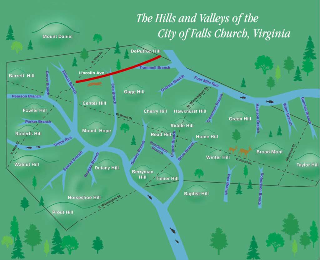
The City has been working on modeling our watershed resilience, collecting data on the stormwater infrastructure and assessing flood risks. 80% of the City’s area has been completed to date. The picture below shows that Lincoln Avenue starts near the Ellison Branch at West Street and crosses the Coe Branch, both of which belong to the larger Tripps Run watershed, as well as the Trammel Branch, shown in the yellow and orange areas in the Four Mile Run watershed. The black and yellow lines are the storm drains that have replaced these streams. They run along the backyards of houses and some streets.
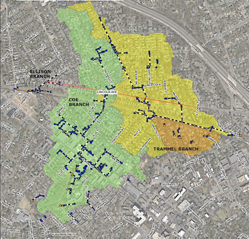
An analysis of the areas of the flood risks shows that the vulnerable areas roughly trace the old paths of these streams that have been diverted into underground storm drains. The pictures below show the expected flooding from 10-year storms.
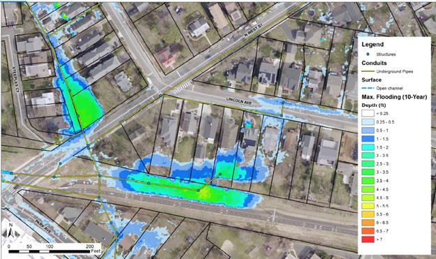
The backyards of properties in the west end of Lincoln Avenue, lying in the Ellison Branch watershed pictured above, had high flood risks. These have been ameliorated by the recent drainage improvements on the W&OD Trail. The remaining risks on Lincoln Avenue itself can be handled by the infrastructure improvements proposed here.
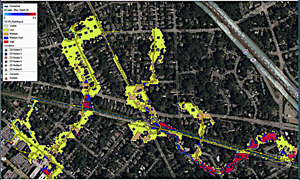
Toward the east on Lincoln Avenue, the analysis shows three locations of significant flood risks, at the intersections with:
- Greenwich St towards N Lee St (Coe Branch)
- Great Falls St (Trammel Branch)
- Walden Ct (Trammel Branch)
These are not so easily fixed despite the drainage work on the W&OD Trail (blue-black dashed line), but this project is intended to tackle those problems.
Project scope
In 2022, funding opportunities became available to improve the City’s stormwater infrastructure, and the City began work on this project in August 2022. The stormwater infrastructure goals are:
- Localized flood control
- Increased water quality
- Construction of green infrastructure such as bioretention areas to reduce the rate of flow of stormwater
- Adoption of current ordinance
The City engineers recommended taking advantage of this work to improve the sidewalk and roadway as well, with these goals:
- Rebuild sidewalks to ADA+ compliance (5 ft width, ramps)
- Add traffic calming features – speed limit reduced to 20 mph
- Additional street trees and other greenery
- Traffic/Pedestrian/Biker safety features – e.g. crosswalks, signage, bus stop areas
The bike lanes on the Arlington County side of Lincoln Avenue (Fairfax Drive) will not be extended beyond Yucatan Street. Also, a significant number of parking spaces currently available along Lincoln Avenue will be replaced with green infrastructure. All work is to take place within the City’s right-of-way.
Funding for the Greening of Lincoln project
The Greening of Lincoln project is budgeted to cost about $8 million. The City has access to state and federal grants for stormwater projects. The City also has access to $4.8 million from US American Rescue Plan Act of 2021 (ARPA) for stormwater projects and $2.7 million from Roadbed Reconstruction Revenue Sharing, for a total of $7.5 million. The City will have to make up the remaining $0.5 million if other sources are not found.
The project is in its early stages, but a construction contract will need to be in place by the end of 2024 if it is to receive ARPA funding. Construction must be finished by December 2026.
What are the neighbors’ concerns?
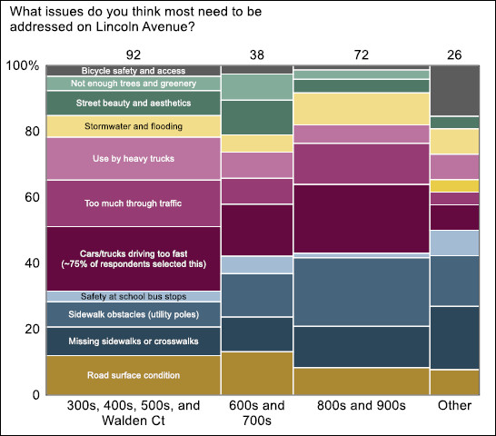
Early in 2021, some residents of Lincoln Avenue sent a joint letter to the City to alert them to the deteriorating condition of Lincoln Avenue. The residents organized a survey to which 58 Lincoln Avenue residents (60%) responded. Survey results were summarized in a letter from the residents in February 2022.
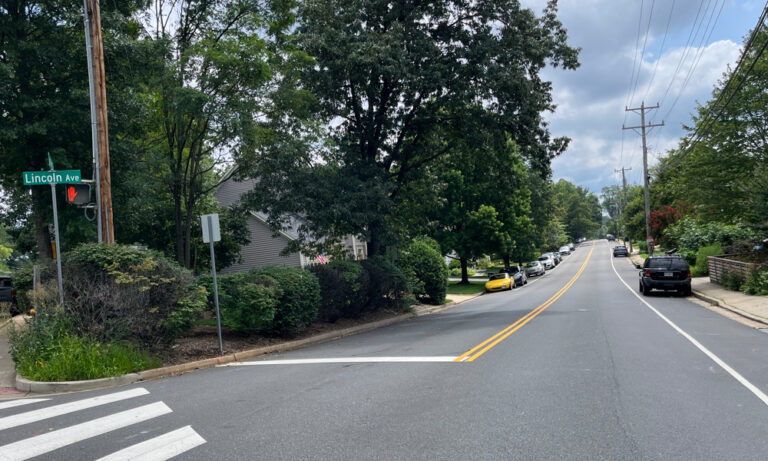
Traffic safety: Traffic on Lincoln Avenue is heavy and includes trucks. Residents report that traffic often exceeds speed limits. The street is unsafe for bikers, school buses, and pedestrians attempting to cross it. Residents would like to see traffic calming features on this street.
Sidewalk condition: Sidewalks are typically 3 to 4 ft wide with utility poles in the middle of the walkway in many places. There are also “missing links” in the sidewalks along the street.
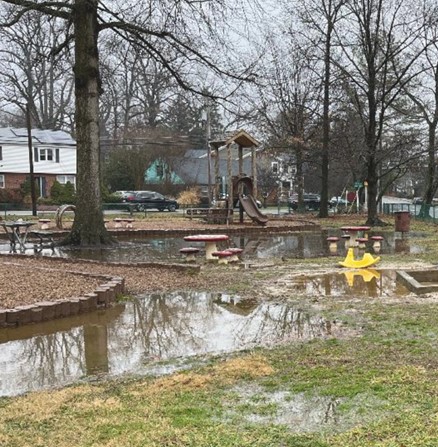
Stormwater and greenery: Some properties on Lincoln Avenue and just off Lincoln Avenue experience regular flooding.
The survey also showed that there is ample parking on Lincoln Avenue, providing an opportunity for some spaces to be repurposed to address the concerns the survey identified.
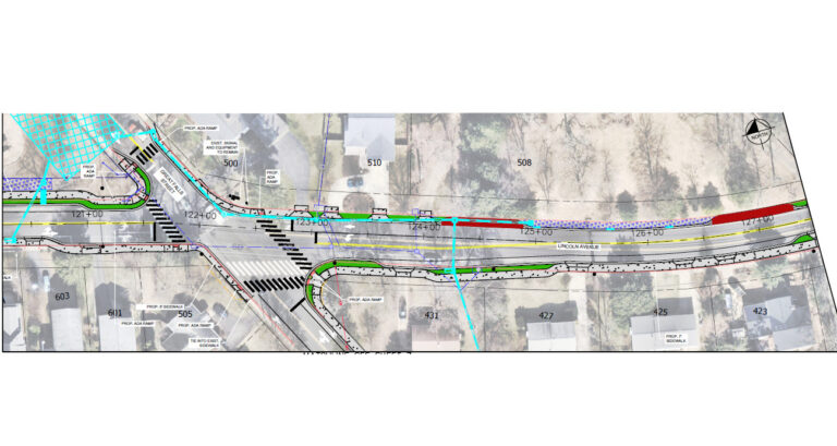
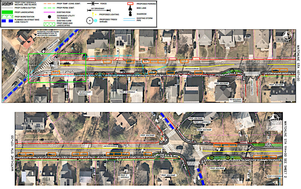
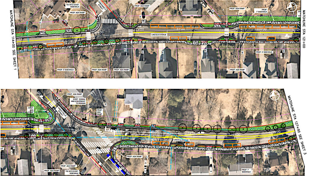
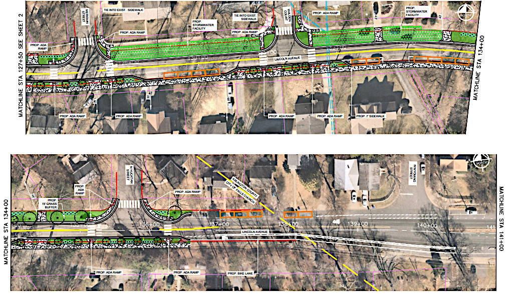
The 15% design
Plan features include:
- A sidewalk on the south side from West Street to the Arlington County line. A sidewalk on some sections on the north side. Sidewalks will not be impeded by utility poles.
- Parking areas are shown as orange boxes, each box is 22 ft long. The current 194 spaces are to be reduced to 68 spaces in this plan. Staff pointed out that parking could be higher than shown, as some spaces between driveways were just under 44 ft so that only one box was marked. Currently, the available parking is underutilized. On the north side of the street, staff estimate a third of the spaces are used, while about half the spaces are used on Lincoln Avenue’s south side. The final number of parking spaces in the plan will consider public input.
- The road will be narrowed, with a speed limit of 20 mph.
- Green areas denote bioretention areas that are designed to hold and filter stormwater.
- The bike lane from Arlington will be extended only to Yucatan Street.
- Bike sharrows signs will be painted on Lincoln Avenue to indicate shared lanes.
- Additional street trees will be planted.
- The design will consider the safety of school bus drop-off areas and crosswalks.
The 15% design presented to Council is shown below. Staff are modifying this based on input from Council and CACT before seeking public input.
CACT and Council comments
Both CACT and the City Council were concerned about public reaction to the removal of parking spaces. Tony Dudley, the City stormwater engineer in charge of this project, stressed that public support is important. He explained the trade-offs between having space for effective bioretention structures, parking, and constraining work to the City’s right-of-way. Mr. Dudley said that public engagement will be critical in informing how much parking to repurpose in the final plan to achieve the goals of the project.
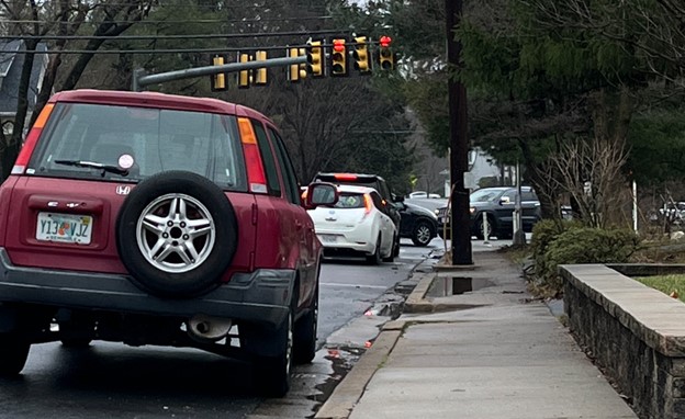
At the CACT meeting in October 2023, members were also concerned about traffic safety and how to slow the traffic using speedbumps and raised crosswalks. The intersection of Lincoln and Great Falls Street is very wide and encourages speeding. CACT members brought up sightline issues when making turns onto Lincoln Avenue.
At the January 16 meeting, Council members were concerned about engaging the public, especially on the parking issue. Council member Justine Underhill asked if the road could be further narrowed to slow down traffic. She also raised the issue of Lincoln Park being flooded after heavy rains and whether this project would alleviate that problem. The City Council urged staff to consider a bike lane down the length of Lincoln Avenue.
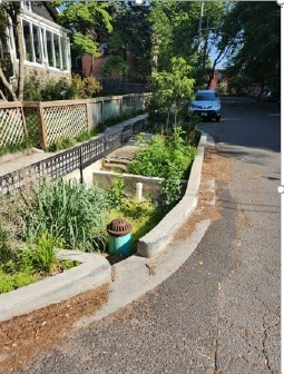
Examples of bioretention structures
Bioretention structures are designed to hold stormwater, allowing it to be absorbed and naturally filtered by the earth. Excess stormwater can seep out at a slower rate that mimics the natural process. This helps to ensure that the City’s storm drains can handle the peak flow rates during a heavy storm. Below are examples of such structures.


References
- Citizens Advisory Committee on Transportation meeting, October 11, 2023. This video will not display properly on a small screen as it includes an agenda portion.
- Responses to Comments from CACT meeting, October 2023.
- Greening of Lincoln Presentation, Tony Dudley, October 11, 2023.
- Greening of Lincoln Concept Plan, January 2024.
- Greening of Lincoln Survey Findings, February 22, 2022.
- City Council Work Session, January 16, 2024, video and agenda. This video will not display properly on a small screen as it includes an agenda portion.
- City Council Work Session, January 16, 2024, YouTube video
- Staff Status Update for Greening of Lincoln Project v2