Elements of the 2025 Falls Church Bicycle Master Plan
Origins of the Bicycle Master Plan
Since 2010, several attempts have been made to devise plans for travel by bicyclists within the City. The W&OD Trail, built in 1974 and owned by NOVA Parks, was initially the primary bicycle trail through the City. In 2014, the City added sharrows on certain streets to encourage bicyclists to travel in the same lanes as cars and provided wayfaring signs to mark routes from the W&OD to downtown Falls Church.
In 2015 the adoption of a Bicycle Master Plan led to the installation of bicycle lanes on Hillwood, Roosevelt, and South Maple Streets in 2017 and the creation of the W&OD dual trails in 2021. But as the City increasingly focused on a series of major development projects, the rest of the plan for building a network of bikeways fell away. [See the Pulse post The 2024 Bicycle Master Plan, June 2, 2024.]
The current Bicycle Master Plan
As time passed and interest in bicycling grew within the City, a new Bike Master Plan was finally adopted in January 2025. This plan sets out the following goals:
- Goal A: Provide an environment in which bicycling is safe and comfortable for people of all ages and abilities.
- Goal B: Provide safe and convenient access among neighborhoods and schools, parks, shopping, transit, employment and other destinations.
- Goal C: Achieve status as a Bicycle Friendly Community by 2030.
- Goal D: Ensure that Falls Church’s bicycle network connects with those of neighboring communities, and that Falls Church’s network is an integral part of the regionwide network.
- Goal E: Increase bicycling rates and mode share in the City of Falls Church.
- Goal F: Maintain, operate, and grow the infrastructure that supports bicycling in Falls Church.”
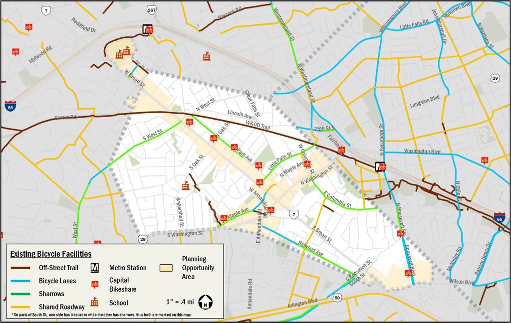
The Master Bike Plan summarizes the current bike network within the City, in addition to the W&OD Trail, as follows:
- “Off-street trails: Cavalier Trail Park, Tripps Run Park, Benjamin Banneker Park, and the connection between Midvale Street and Cherry Street.
- Bicycle lanes: portions of S Maple Avenue, Roosevelt Boulevard, and Hillwood Avenue.
- Traffic calming measures such as speed humps: E Columbia Street and Little Falls Street.
- Sharrows: Park Avenue, Little Falls Street, S West Street, S Maple Avenue, Hillwood Avenue, and E Columbia Street.
- On-street routes: between Benjamin Banneker Park and S Maple Avenue and between Cavalier Park and the W&OD Trail.
These particular roadways were chosen because they:
- run parallel to major roads, West Broad Street (SR 7) and Washington Street (US 29);
- provide access to most commercial areas of the City;
- have relatively low automobile traffic volumes; and
- provide direct access to and from the W&OD Trail.”
Priorities set
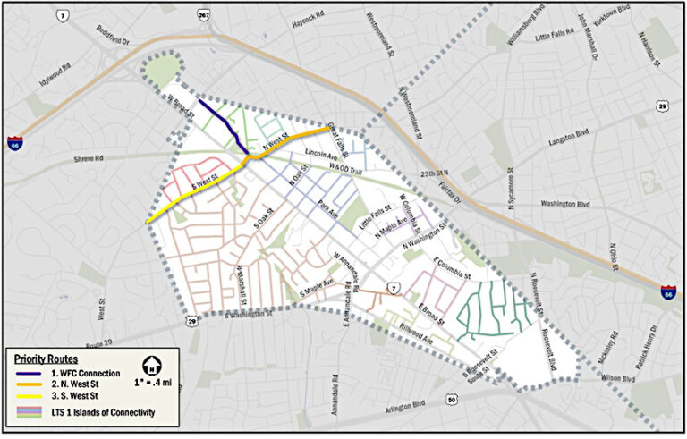
An Appendix to the City’s Bicycle Master Plan sets out priority bike routes “for further exploration and implementation.” The top three priorities for FY2025-FY2027 are:
- East-West Pedestrian and Bicycle Connection between the W&OD Trail and the Secondary Schools Campus,
- North West Street, and
- South West Street.
Specific plans have been discussed with the neighboring communities. Per the Master Plan, “final design will be developed on a block-by-block basis and will accommodate both safety needs and day-to-day operations needs of neighborhood residents. Updated plans will be shared with the affected neighborhood and with Council in advance of construction to ensure these goals are met.”
For FY2028-FY2030, the following routes (listed alphabetically) are indicated for future consideration:
- East Broad Street,
- Great Falls Street, and
- Park Avenue between Virginia Avenue and North West Street.
“This list of future priority routes will be re-evaluated in the FY2028 timeframe to determine current priorities..… Project design and implementation will follow a similar set of steps to the FY2025-FY2027 routes, including an opportunity for public input, alternatives analysis, selection of a locally preferred alternative, final design, and implementation. Public engagement will include direct outreach to the neighborhood and will include neighborhood meetings and walks in the design process for those routes that the City decides to pursue at that time. This public engagement will form the basis for future implementation.”